Maps and Directions to Potato Hill
Directions: (Note – first time to this site, it is highly recommended to drive up during daylight hours. The country roads are very tricky for some to navigate in the dark. You have been warned!)
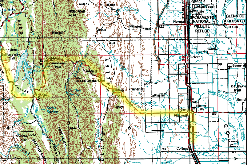
Google Maps to Dixie Glade Campground (Because of bad signal in area, print below directions)
- First, go to Stonyford
- Take I-5 north to Maxwell, about 40 minutes North of Sacramento
- Exit at the first Maxwell exit and then go west on the main road (At the first junction/split, Sites, turn right toward Lodoga.). At Lodoga, turn right and continue to Stonyford (total of 1/2 hr – 40 minutes driving time from Maxwell to Stonyford)
- When you arrive in Stonyford, turn left at the stop sign.
- From Stonyford to LZ, Launch and Campground – To the LZ
- Continue about 1/4 mile and then turn left on Fouts Spring Road (This is the 3rd left)- There are signs to Fouts Spring
- It is about 20 minutes on this road to the LZ. The road will wind up over the hills, then descend down to a valley. When you reach the valley continue and look on the right for the Fouts Spring Youth Facility.
- The LZ is the huge field in front of the vacant buildings on the right side of road. There is a dirt parking lot on the left side of the road for parking.
- To go to Dixie Glade Camp and launch from the LZ continue on the same road up the mountain.
- To CAMPING: Watch on the right for the sign for Dixie Glade campground, about five miles past the Youth Facility. Coordinates for Dixie Glade 39°20’6.81″N and 122°42’13.09″W At present “2020”, Dixie Glade is now open again, after closure from a huge fire a few years ago. If you continue on the road, about 20 – minutes up the road, you will come to Letts Lake and there is a campground there. If your GPS works, you can use the GPS: Lat – 39° 18′ 10.238399″, Long – 122° 42′ 27.6948”
- To LAUNCH: The road to launch is the first turn-off on the left after you pass Dixie Glade. Take this left and follow the main dirt road up until it “T”s into a road at the top of the ridge.
- Turn left and follow this until it makes a 90 degree right turn and becomes steep. There is a trail-head and room to park at this elbow. The Trail at this elbow goes to the Potato Launch. The hike is about 10 – 15 minutes and has not intersections, just stay on the trail.

Looking out from Launch

Driving from LZ to Letts Lake Campground

 - Paragliding Lessons in the San Francisco Bay Area")
Potato Hill Flying Site – Basic Flight Plan
Potato is technically unregulated. In the summer season, midday flying can lead to landing in a extremely, thermally active, LZ. If Potato were regulated, it would likely be a P3 site with sponsorship for P2s. Pilots flying as low skilled P2s should at minimum have more experienced pilots with them and also have a solid grasp on weather checks. The most important concern at Potato is when west winds blow strong and the LZ gets mixing air from the 3 canyons that connect there. This is a recipe for accidents. Also, it can blow over the back and pilots on launch might not be aware. This can be prevented to checking the wind on the way to launch as you walk out the Potato Hill ridge to launch. Always do this and check to ensure it is not blowing over the back.
Below is an overhead photo of Potato Hill. The two most common flight paths used at this site are either following the ridge to the left of launch down and veering slightly to the right to the LZ, or, using the Haybails route (note, I realized after creating this that hay bales is incorrectly spelled, but, until I have more time, it was too much work to fix at present).
On flights where lift and thermals are encountered, a pilot can climb and have freedom to look for more thermals and not have to keep moving towards the LZ. Should a pilot start to lose lift and begins descending again, the flight plan dictates to continue on the primary path toward the LZ. If well up (easy or super easy glide to the LZ, moving around a bit above the general area is fine.
Potato Hill – Two Common Primary Paths
I normally find better lift on the spine route, but either can work good for flight. Many think the Hay Bails is the best thermal, but the most consistent thermal at Potato is the one on the ridge to the left of launch. Also, this path usually provided easier ability to reach the LZ with some extra height.
Click on pictures for larger images …

The coordinates of the new LZ are: 39°21’6.76″N and 122°39’40.86″W
